

This week’s circular walk takes you on a trip around the grounds of Newstead Abbey and through the picturesque villages of Linby and Papplewick.
Distance: 5.4 miles (8.78 km)
Calculated time: 2h 40
Difficulty: Easy
Map of the walk
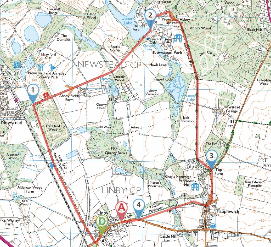
1. Top Cross in Linby village
From the Top Cross in Linby village walk up the hill to the traffic island. Turn right onto the path signed Linby Trail and National Cycle Network. This is along a railway cutting which follows the route of the Great Northern Railway. This straight path continues for some
considerable time until some large boulders are seen ahead partially blocking the path. Here the path turns sharply to the right still signposting the National Cycle Network alongside a woodland walk.
The path then joins a tarmac road at one of the lodges to Newstead Abbey estate. Passing through this gate (there is no charge for walkers) follow the road until Newstead Abbey ruins come into view. The road is mostly flat apart from a couple of short climbs through glades. As the road descends towards Newstead Abbey the upper lake and stable block can be seen to the left followed by a waterfall and then the magnificent aspect of Newstead Abbey comes into view with the garden lake to the right.
2. Newstead Abbey grounds
Follow the road round to the left between the ruins and the upper lake. Ahead is the stable block and bell tower. After passing a car park on the left and the cricket pitch to the right there is a crossroads. Turn right here and follow the tarmac road winding through the woods until a pair of wrought iron gates appears ahead. This it the entrance to another lodge, a footpath for walkers is marked to the right of the gates and follows alongside a hedge. At the other end there is a metal kissing gate to pass through before following a wide grassy path ahead with hedges on either side. At the end proceed through a metal gate and onto an unmade road which bears to the left and has large properties on either side. Follow this road called Hall Lane until a tree can be seen ahead in the middle of a small grassy area with a seat where the path meets the main road B683. Papplewick Hall can be seen immediately to the right at this junction.
3. Passing through Papplewick
Turn right along the road, with a footpath, following it into Papplewick village. It bears sharply right past a row of cottages and then right where there is a wide gap after Papplewick lodge showing a sign to The Church of St James Papplewick and a public
footpath signposted to Linby. Pass through the wooden gate and follow this tarmac road in the direction of the church, Before reaching the church there is a well trodden signed path on the left through the fields to Linby. At the end of the field pass through a metal gate and over a wide footbridge over the river Leen and then continue alongside a hedge bordering an arable field until it emerges onto the main road B6011 into Linby.
4. Back to Linby
Turn right and follow this road into the village passing the Bottom Cross on the right and the old village school. On the left hand side, next to the bus shelter is an interesting Parish Map of Linby explaining the history of the village. Continue up the hill to the Top Cross to the start of the walk
- Have you got a suggested walk around the borough you want to share with our readers? You can email details to news@gedlingeye.co.uk


